


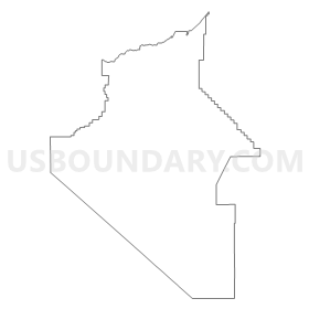
Carson City, Lyon, Douglas & Storey Counties PUMA, Nevada
About
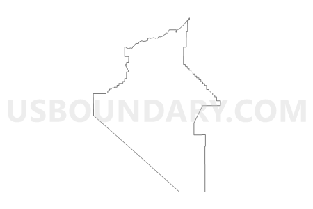
Outline
Summary
| Unique Area Identifier | 193352 |
| Name | Carson City, Lyon, Douglas & Storey Counties PUMA |
| State | Nevada |
| Area (square miles) | 3,182.73 |
| Land Area (square miles) | 3,118.49 |
| Water Area (square miles) | 64.24 |
| % of Land Area | 97.98 |
| % of Water Area | 2.02 |
| Latitude of the Internal Point | 39.04195570 |
| Longtitude of the Internal Point | -119.37367240 |
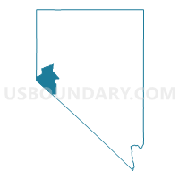
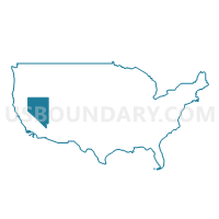
Maps
Graphs
Select a template below for downloading or customizing gragh for Carson City, Lyon, Douglas & Storey Counties PUMA, Nevada


Neighbors
Neighoring Public Use Microdata Area (by Name) Neighboring Public Use Microdata Area on the Map
- Alpine, Amador, Calaveras, Inyo, Mariposa, Mono & Tuolumne Counties PUMA, CA
- El Dorado County--El Dorado Hills PUMA, CA
- Placer County (East/High Country Region)--Auburn & Colfax Cities PUMA, CA
- Rural Nevada PUMA, NV
- Washoe County (North)--Sparks City PUMA, NV
- Washoe County (South) PUMA, NV
Top 10 Neighboring County (by Population) Neighboring County on the Map
- Washoe County, NV (421,407)
- Placer County, CA (348,432)
- El Dorado County, CA (181,058)
- Carson City, NV (55,274)
- Lyon County, NV (51,980)
- Douglas County, NV (46,997)
- Churchill County, NV (24,877)
- Mono County, CA (14,202)
- Mineral County, NV (4,772)
- Storey County, NV (4,010)
Top 10 Neighboring County Subdivision (by Population) Neighboring County Subdivision on the Map
- Reno Southeast CCD, Washoe County, NV (69,660)
- Carson City CCD, Carson City, NV (55,274)
- Warm Springs-Truckee Canyon CCD, Washoe County, NV (52,378)
- South Lake Tahoe CCD, El Dorado County, CA (30,728)
- Gardnerville-Minden CCD, Douglas County, NV (30,220)
- Fallon CCD, Churchill County, NV (24,678)
- Fernley CCD, Lyon County, NV (19,519)
- Dayton CCD, Lyon County, NV (15,276)
- Washoe Valley CCD, Washoe County, NV (12,741)
- Lake Tahoe CCD, Placer County, CA (10,448)
Top 10 Neighboring Place (by Population) Neighboring Place on the Map
- Carson City, NV (55,274)
- South Lake Tahoe city, CA (21,403)
- Fernley city, NV (19,368)
- Gardnerville Ranchos CDP, NV (11,312)
- Dayton CDP, NV (8,964)
- Johnson Lane CDP, NV (6,490)
- Gardnerville CDP, NV (5,656)
- Indian Hills CDP, NV (5,627)
- Silver Springs CDP, NV (5,296)
- Yerington city, NV (3,048)
Top 10 Neighboring Unified School District (by Population) Neighboring Unified School District on the Map
- Washoe County School District, NV (421,407)
- Carson City School District, NV (55,274)
- Lyon County School District, NV (51,980)
- Douglas County School District, NV (46,997)
- Tahoe-Truckee Joint Unified School District, CA (31,699)
- Lake Tahoe Unified School District, CA (29,839)
- Churchill County School District, NV (24,877)
- Mineral County School District, NV (4,772)
- Eastern Sierra Unified School District, CA (4,258)
- Storey County School District, NV (4,010)
Top 10 Neighboring State Legislative District Lower Chamber (by Population) Neighboring State Legislative District Lower Chamber on the Map
- Assembly District 4, CA (536,793)
- Assembly District 25, CA (475,252)
- Assembly District 32, NV (80,177)
- Assembly District 26, NV (69,333)
- Assembly District 38, NV (66,836)
- Assembly District 25, NV (65,059)
- Assembly District 36, NV (59,012)
- Assembly District 39, NV (53,415)
- Assembly District 35, NV (51,108)
- Assembly District 40, NV (49,877)
Top 10 Neighboring State Legislative District Upper Chamber (by Population) Neighboring State Legislative District Upper Chamber on the Map
- State Senate District 1, CA (1,002,597)
- Washoe County Senatorial District 2, NV (136,694)
- Central Nevada Senatorial District, NV (113,138)
- Washoe County Senatorial District 4, NV (110,453)
- Capital Senatorial District, NV (102,155)
Top 10 Neighboring 111th Congressional District (by Population) Neighboring 111th Congressional District on the Map
- Congressional District 25, CA (844,320)
- Congressional District 2, NV (836,562)
- Congressional District 3, CA (783,317)
- Congressional District 4, CA (774,261)
Top 10 Neighboring Census Tract (by Population) Neighboring Census Tract on the Map
- Census Tract 9601.01, Lyon County, NV (10,653)
- Census Tract 9603.02, Lyon County, NV (9,521)
- Census Tract 9601.02, Lyon County, NV (7,143)
- Census Tract 22, Douglas County, NV (6,657)
- Census Tract 6, Carson City, NV (6,382)
- Census Tract 5.01, Carson City, NV (6,102)
- Census Tract 9507, Churchill County, NV (5,701)
- Census Tract 32.02, Washoe County, NV (5,670)
- Census Tract 15, Douglas County, NV (5,656)
- Census Tract 9609, Lyon County, NV (5,468)
Top 10 Neighboring 5-Digit ZIP Code Tabulation Area (by Population) Neighboring 5-Digit ZIP Code Tabulation Area on the Map
- 89502, NV (43,566)
- 96150, CA (29,792)
- 89701, NV (27,625)
- 89521, NV (25,716)
- 89434, NV (25,416)
- 89406, NV (24,772)
- 89408, NV (19,626)
- 89706, NV (19,510)
- 89403, NV (14,158)
- 89460, NV (13,236)